The trail down to the canyon floor is beautiful. I call it the mini Grand Canyon. Remember it is 2000 feet of climbing coming back out!
The trail down to the canyon floor is beautiful. I call it the mini Grand Canyon. Remember it is 2000 feet of climbing coming back out!
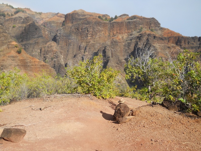
On December 9, 2012 I revisited Waimea Canyon Trail via Kukui Trail. Below is a writeup I did last year when I completed a one-way hike down the canyon to the town of Waimea. Not much is available on this hike so I decided to post it since the information is still valid. The big difference for this hike was the water level of Waimea River. Last year I was crossing knee-hike to thigh-high water that was murky red. Although the water was warm, the 14 crossings were challenging. I now know, from talking to an experienced Waimea Canyon hike leader, that the river only runs deep red when it is high, and should be crossed at these times by folks who have done these types of crossings before. It is probably not a good idea to do the hike under these conditions alone.
However, a year later the hiking conditions were totally different. The hike down Kukui Trail was easy because it was dry, therefore, not as slippery when wet like last year. However, it still drop 2,000 in 2.5 mile so it is steep in part and can be tricky. When I reached Waimea River I was stunned with how low it was. I had brought my Teva sandals in my daypack anticipated the river crossings, but the water was so low I could easily hop across rocks without getting my feet wet. If I had hiked the Waimea Canyon Trail down to Waimea this time, the hike would have been moderate rather than strenuous.
Crossing the river last year 14 times when the river was high was tiring. I had my car this time at the Kukui Trailhead so I hiked up Waimea Canyon instead of down. I am taking an educated guess, that if you go down river when the water is very low you will not need to cross back and forth so much. Please comment on my blog if you hike down the canyon. I did discover why the river was so low — up river the water was being diverted into a large drain/dam. I have no idea if this is going to permanently impact the water level in Waimea River; however, locals in the town of Waimea did make comments about someone diverted the water and fish were now dying. Who knows for sure. Corn has now replaced the sugarcane crop. Perhaps it is taking more water from the river on the dry side of Kauai.
Writup on Waimea Canyon Trail to town of Waimea:
On November 4, 2010, I hiked from Kukui Trail in Waimea Canyon to the town of Waimea. I started at 8 am from the Trailhead which is located between mile marker 8 and 9 on highway 550. The 2.5 mile hike down was uneventful, but a little slippery with mud, loose dirt and rocks. Look for trail and stay off the cuts to switchbacks. Once you reach trail marker 1.75 the trail enters the forest. The trail was easy to follow but in spring could be overgrown.
At the bottom was a backpacking camp with a pit toilet. The site was covered with cherry plums on the ground and smelled like rotting fruit. I walked straight down to the river and was dismayed to see how high the river looked. however, this was not the trail. I backtracked and found a sign that had Waimea Canyon Trail down the road to the right. Soon the first river crossing appears. It took me some time to figure the best place to cross. The entire trail down Waimea Canyon is mostly a soft, red dirt road. However, there are 14 river crossings as the trail goes from side to side. After a mile and six river crossings I came to a power station and found a man working would told me that there were 14 river crossings in total. Also the river only gets slightly larger with most of the water coming from deep in the park and not from side streams. So, no need to worry about that — just worry about the storms upstream that may cause flash flooding. Watch on the river crossings to see if the water is getting higher. I am not sure the total distance from the backpacking camp to the beginning of the paved road to Waimea but someone scratched 9.5 in the sign so I am using that. There is one long section that climbs a bit on the left side of the canyon so feel free to put the hiking boots back on. The road follows the ditch for quite a while and then the road cuts up hill after crossing a metal bridge. Continue straight on a foot trail that follows the ditch. it will join back up to the road in a half mile.
Soon the road takes a turn back down to the river. The road is made of rock on this part as it drops 200 feet back down to cross the river again. just when I was getting use to dry hiking. A note on the river crossings – the water is brown from the red dirt and hard to see the bottom so step carefully. A hiking pole is really helpful. Do not lift your foot up before you are sure the other is securely planted. Look at the crossing to see where the vehicles are crossing so you can cross at the shallow part. Not always easy to see, especially when the river runs red.
Yesterday I took off work early to tackle Rhus Ridge to Black Mountain again. This time the weather was clear and cool and it took me 3.5 hours to complete the 9.6 miles, 2400 feet of climbing. The parking lot on Rhus Road is small, and remains a problem for starting hikes from here, especially on weekends. It was a nice day, and when I arrived at 3 pm on a Monday there was only one spot left in the lot. There is no parking along the road. I would suggest hikers drive the extra mile down the main road and begin the hike on the Hostel Trail in Hidden Villa if the lot is full. It is similar in distance to the top of Black Mountain and Hidden Villa has ample parking (they do charge a nominal amount.) Please read my previous blog on the Rhus Ridge hike for more information. The trail is the same, it only feels different depending on the weather.
I spent another great day hiking The High School Trail in Fall Creek. Please read my earlier blogs for the location of the park and trailhead. On weekends, I continue to prefer starting my hike from San Lorenzo High School rather than the dusty, small parking lot off of Empire Grade Road. Yesterday I hiked the mile long High School Trail to the S-scape Trail, continuing up to the Truck Trail, which is actually a dirt road. There are now two trails one can take down to the South Fork Fall Creek Trail. Both come in from the left and have no signs. The first trail is a new one – I am not sure it was built by the park staff but it is easy to follow, if you can follow trail markers. The trail is on the left about 1/2 miles down Truck Trail. It is currently marked with two 7 foot tall poles stuck in the ground. This trail is less than a mile, and drops you down just before the Barrel Mill Site. If you continue climbing up the Truck Trail road for another 1/2 mile you will see The Big Ben Trail on the left, currently marked with bright pink surveyor tape wrapped around a redwood tree. The sign has been missing for about a year now. Yesterday I chose this trail down. It is a little longer and steeper than the first trail. I took a left at the intersection at Fall Creek and headed back down the South Fork. After passing the Barrel Mill Site you will see the unmarked trail on the left that was previously described.
Continue down the South Fork, crossing foot bridges and other trails. Take the trail toward Fall Creek Drive. If you just take all the trails to the left, you will find your way back to the High School Trail. If you find yourself at Fall Creek Drive, no worries, just backtrack 1/4 mile and look for the sign to the high school on the right. Take the mile long trail back to the school. Total hike took me 3 hours so it is around 7 miles with 600 feet of climbing.
Just a quick update on finding the High School Trail for Fall Creek in Felton. The trail does start behind the San Lorenzo High School stadium; however, there is construction going on at the elementary school next door so you have to walk around it all by the swimming pool. Also, many of the locals have walked their dogs on this trail for years but the state has now posted a “no dog” sign. It doesn’t seem to stop people, though. This is still a gorgeous, mostly level trail surrounded by redwood trees. It is a much better entrance into Fall Creek on the weekends. There is plenty of parking at the high school.
Just an update on my blog on Rancho San Antonio about hours that the park is open. Because the park is so heavily used, and rangers want to keep people from parking in the neighborhoods (Cristo Rey Drive and Hammond Way, Cupertino, CA ), the park usually opens around 5:30 a.m. and closes after 8 p.m. Only one gate is closed so people can still drive out even if the entrance gate is closed. This park is very crowded on weekends so it is difficult to find parking on weekend mornings, especially around 8-9 a.m. If you can’t find parking in the three available lots, you can park about a mile back down the main road and walk up the Hammond Synder Loop Trail which opened in 2006 but is not on the Santa Clara County’s park map.
I have been hitting the trail pretty early these days on the PG&E Trail at Rancho San Antonio. One day the gate was locked at 7 am even though the hours said from dawn to dusk. Inside the park the hours are posted from 8am to 5pm. So what are the true hours of the park? I asked a park ranger the other day and he told me he wasn’t quite sure because the gates are on an automatic timer, but he thought it opened by 6am or 6:30am at the latest. One day there was a malfunction so it did not open until 7:30 am although people could get around because the exit no longer had the metal prongs that stick up to slash tires. Apparently, the dawn to dusk rules doesn’t apply during winter when users of the park still come in during their usual hours. I assume it also stays open past dark.
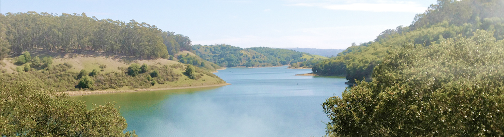
Hike facts: From Grant Lake to Antler Point and back in a reverse figure eight (map shows 9.6 miles, GPS recorded 10.9 miles). 1900 feet of cumulative elevation gain. 4.5 hours hike with only a brief stop for lunch. Trail map of Joseph Grant Ranch Park.
Yesterday I led a hike for Loma Prieta Sierra Singles and managed to get three hikers to join me in a moderately paced hike in Grant Ranch Park just below Mt. Hamilton. We began the hike from the parking lot 1/4 mile past the main entrance on the left side of the road. Radio Ham operators were setting up in the parking lot and a few road bikers were hanging out before making the climb up the road. It was a perfect sunny and cool day for the hike. I had reminded folks that we were hiking to 3,000 feet so it might be cooler at the top and it was often windy.
We headed out along Grant Lake and after 1/2 took the Halls Valley Road up the hill. The hike is almost all on ranch roads although the park refers to them as “trails.” Except for the short single track to the point, all roads also allow dogs on leashes. Most of the climbing for this hike occurs in the first half of the hike. Half way up the road we saw three wild pigs on the next hill, it didn’t take long to find one of their hangouts which was a wet spot along the road that was worn down with pig tracks. Wild pigs have long been a problem in this park. At the top the trail meets up with Canada de Pala Trail and you take a left turn and gradually climb up the road toward the point. Another road intersects in a mile but stay to the right on Pala Seca Trail. There was signs of control burning along this section — there should be great wildflowers here next spring! Continue on the road until you reach a single track trail that will take you the last 1/2 mile to Antler Point. In a previous writeup I said the point was really on a faded trail to the right overlooking the east. This is really an old volunteers hangout. The real point is somewhere below the bench at the top. Have lunch here and enjoy the view but be prepared for some wind.
Returning we backtracked to the road and made a right turn and headed down to the hunting cabin that is being restored by a volunteer. There is a writeup on the wall about President Hoover visiting to fish in the area. The cabin also has a picnic table on the porch which is a good alternate lunch stop if the point is too cold. Continue down Canada de Pala Trail and you will notice some work being down in a meadow to the left. This wetland high meadow is being restored by the county. Here we spotted a coyote hunting the plentiful ground squirrels.
You soon pass and intersection to the right to Washburn Trail but continue on the same road until you meet up again with Pala Seca Trail. Head back down to the right, staying on Canada de Pala Trail. Pass the Halls Valley Road until you come to the Los Huecos Trail. Head down the road on the right. This road is steep in spots. We saw a nice looking four-pointed buck here who didn’t seem to mind us. At the bottom you meet back up with the Halls Valley Road. Turn left and complete your hike back to the parking lot.
I love this hike because of the open hills and great views. It is also a pretty good workout with 1900 feet of climbing and 9.6 to 10 miles. I don’t believe the GPS reading of 10.9 but I will have to try it again. If you add up the mileage on the County park map above it is 9.6 miles.
Just the facts: 9-10 miles, 2000 feet climbing, 4 hours.
I went back to Fall Creek to scout out the new unmarked trail I found last week. Of course, after doing this hike I realize it is on the excellent San Lorenzo Valley trail map put out by Redwood hikes — just not marked. As usual, I began at the San Lorenzo Elementary School parking lot off Highway 9 just east of Felton. To find the trailhead to the High School Trail locate the football stadium and head to the back of the bleachers. You will see a road that goes between the childcare center and enviromental site. Take this road and you will soon see a wood bridge on the left. Cross here and you are now entering the Fall Creek part of Henry Cowell State Park.
There are no dogs or bikes allowed here but everyone seems to ignore the dog rule. High School Trail is a beautiful one mile, relatively flat, trail through the redwoods. Today, I head up the Ridge Trail for 1.1 miles and connect with the short S-Cape Trail. The S-Cape Trail drops down to the Fall Creek Trail. Fall Creek Trail is where 80% of the hikers walk. It is a pretty walk but if you want to avoid the crowds just hike the surrounding trails. Take a right on the Fall Creek Trail and you will have an easy stroll along the creek.
After 1/2 mile begin looking for signs of the unmarked trail. Of course, there are many trails going down to the creek so it is best to keep watch for the beam bridge that crosses the creek — not downed trees but a foot wide beam. The trail is about a 100 yards before you get to the Barrel Mill Site. So if you reach the mill site turn about and back track to the unmarked trail.
I decide to give the wooden beam a try today and easily cross it. It is solid and only about 8 feet above the creek — not as high as it seemed coming down the hill last time! The trail is well-built and I wonder if it will be open to general use someday. I find it easier to go up, avoiding the slippery, steep section coming down near the top. There is one spot where you need to climb under a huge downed tree, that horses cannot pass, so it appears to be a hikers-only trail.
The trail has switchbacks and in one area there are trees that have been cleared using an axe rather than a saw, another sign that this is not a park authorized trail. Either that, or volunteers did not like chainsaws. It takes me about 20 minutes to reach the Lost Empire Trail so the trail is under a mile. The trail is well used so many folks have discovered the short-cut.
Turning left on the Lost Empire Trail it is only about a minute walk to Lost Camp. From Lost Camp I continue on the Lost Empire Trail, taking about 30 minutes to reach the summit and the Big Ben tree and, thus, the Big Ben Trail. Contining down I cross Fall Creek and meet up with the Fall Creek Trail in another 30 minutes. From this trail intersection Barrel Mill Site is another .6 miles so I estimate that the unmarked trail cuts about 2.5 miles off of the usual loop. In another 10 minutes I pass the mill site and continue walking on Fall Creek Trail toward Fall Creek Drive. DO NOT take the Bennett Trail which go right toward the parking lot on Empire Grade Road. Around 1/4 mile before Fall Creek Drive the High School Trail joins back up on the left. Fall Creek Drive is another entrance to the park but there is no street parking.
The High School Trail is one mile back to the high school. The elementary and middle school sits just above the high school.
It was Friday so I knew I couldn’t park at the San Lorenzo High School so I began this hike from the main dirt parking lot off of Empire Grade Road about two miles above Felton. I headed up to the Lime Kilns and then was planning on doing the loop up to Big Ben and back down Fall Creek. However, once I got to Lost Camp I realized I needed to get back so turned around to back track.
About 100 yards from Lost Camp I spotted a trail headed down from the left of the trail. I decided I had enough time to go exploring a little. The trail was obviously built by someone. Although it was steep by today’s trail standards it was a good trail with shovel marks that showed someone put a lot of work into it. The trail traversed below the Lost Empire Trail and then turned back in one long switchback, heading down toward Fall Creek. It was a good trail but was covered with fall leaves so had to pay attention. Any false trails were covered up to keep folks on track. Whoever made this trail wanted to make sure people didn’t get lost! The trail went down steeply and ended at a large beam bridge over Fall Creek that met up with the Fall Creek Trail. It didn’t look particularly sturdy to me, and was narrow so I elected to rock hop over the creek — easy to do in August but much harder in winter.
I was now on Fall Creek Trail with the barrel mill site down the trail to the left. This trail is great and probably knocks about a mile off of the regular loop trail. Next time I will pay more attention to distance. I hiked back up Fall Creek to the Lime Kiln Trail and out to the parking lot. About 3 hours and 1,500 of climbing. Maybe 7 miles or more.
