Hike facts: From Grant Lake to Antler Point and back in a reverse figure eight (map shows 9.6 miles, GPS recorded 10.9 miles). 1900 feet of cumulative elevation gain. 4.5 hours hike with only a brief stop for lunch. Trail map of Joseph Grant Ranch Park.
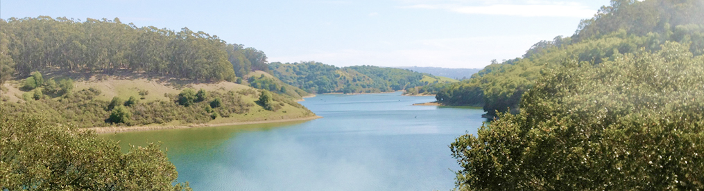
Yesterday I led a hike for Loma Prieta Sierra Singles and managed to get three hikers to join me in a moderately paced hike in Grant Ranch Park just below Mt. Hamilton. We began the hike from the parking lot 1/4 mile past the main entrance on the left side of the road. Radio Ham operators were setting up in the parking lot and a few road bikers were hanging out before making the climb up the road. It was a perfect sunny and cool day for the hike. I had reminded folks that we were hiking to 3,000 feet so it might be cooler at the top and it was often windy.
We headed out along Grant Lake and after 1/2 took the Halls Valley Road up the hill. The hike is almost all on ranch roads although the park refers to them as “trails.” Except for the short single track to the point, all roads also allow dogs on leashes. Most of the climbing for this hike occurs in the first half of the hike. Half way up the road we saw three wild pigs on the next hill, it didn’t take long to find one of their hangouts which was a wet spot along the road that was worn down with pig tracks. Wild pigs have long been a problem in this park. At the top the trail meets up with Canada de Pala Trail and you take a left turn and gradually climb up the road toward the point. Another road intersects in a mile but stay to the right on Pala Seca Trail. There was signs of control burning along this section — there should be great wildflowers here next spring! Continue on the road until you reach a single track trail that will take you the last 1/2 mile to Antler Point. In a previous writeup I said the point was really on a faded trail to the right overlooking the east. This is really an old volunteers hangout. The real point is somewhere below the bench at the top. Have lunch here and enjoy the view but be prepared for some wind.
Returning we backtracked to the road and made a right turn and headed down to the hunting cabin that is being restored by a volunteer. There is a writeup on the wall about President Hoover visiting to fish in the area. The cabin also has a picnic table on the porch which is a good alternate lunch stop if the point is too cold. Continue down Canada de Pala Trail and you will notice some work being down in a meadow to the left. This wetland high meadow is being restored by the county. Here we spotted a coyote hunting the plentiful ground squirrels.
You soon pass and intersection to the right to Washburn Trail but continue on the same road until you meet up again with Pala Seca Trail. Head back down to the right, staying on Canada de Pala Trail. Pass the Halls Valley Road until you come to the Los Huecos Trail. Head down the road on the right. This road is steep in spots. We saw a nice looking four-pointed buck here who didn’t seem to mind us. At the bottom you meet back up with the Halls Valley Road. Turn left and complete your hike back to the parking lot.
I love this hike because of the open hills and great views. It is also a pretty good workout with 1900 feet of climbing and 9.6 to 10 miles. I don’t believe the GPS reading of 10.9 but I will have to try it again. If you add up the mileage on the County park map above it is 9.6 miles.
